The high country trails continue to be a mix of icy snow drifts to hike around or up-and-over and cleared patches. Temperatures so far in June have been pleasantly cool and generally well below seasonal, but are forecast to rise to about average for the month starting Wednesday 21st.
Humber Park, including Devil’s Slide trailhead, will be closed on 12th-14th June due to pesticide spraying work. The area will be closed to both parking and hiking access, according to the closure order posted at Humber this past weekend. [I confirmed that Humber Park had reopened on the evening of Wednesday 14th June.]
Our daily survey hikes include various routes to San Jacinto Peak multiple times per week, typically South Ridge and Spitler Peak trails weekly, and many other trails on intervening days. With the snow rapidly disappearing increasingly the focus of volunteers, including myself, is on trail clearance and maintenance work.
Spikes are no longer required for ascending San Jacinto Peak via the main east and west side routes, nor for other high country peaks, especially given the firmer snow in recent cool weather. On Saturday 10th and Monday 12th June for example, barebooting was relatively straightforward to and from the Peak on upper Deer Springs and Peak trails, respectively, but the previous week spikes had been useful descending to about 9900 ft. Some hikers will find that spikes remain useful in the high country, mainly for descending, but they are no longer required.
Trails above about 9700 ft (west side) and 9900 ft (east side) remain largely, or at least partly, obscured by drifted icy snow. Trails as low as about 8700 ft elevation (on both flanks) have increasingly patchy snow cover, especially on more northerly-facing slopes. Cautious navigation remains important everywhere.
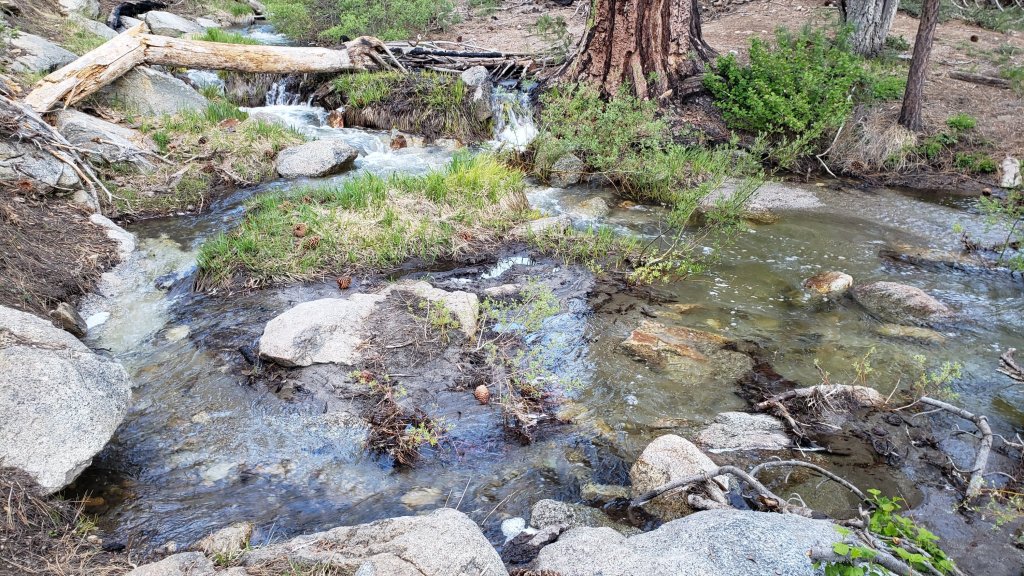
Recently I have had several inquiries regarding water availability for campers in the high country. Given the typically dry conditions of the past decade, such questions are understandable. Currently there is water everywhere, and all possible seasonal and perennial waters, pipes, springs, etc. are flowing well. Personally I have not seen so much water on the mountain since 1998, following the great El Niño winter of 1997/98.
Details of average snow depths measured at various locations on the trail system are given at the foot of this posting, with the greatest snow depth recorded this winter for comparison.
With so much snowmelt, there is a great deal of water in (and under) the trails, and this has also created some tricky stream and river crossings. Lengthy sections of Deer Springs Trail in particular will likely remain ephemeral streams for the next month or so. Appropriate footwear that is at least highly water resistant is strongly recommended. Be cautious of fragile snow bridges over water.
Hikers should anticipate encountering new treefall hazards on trails, along with considerable amounts of debris, branches, cones, etc. While this is partly a consequence of the recent intense winter, most trails in the San Jacinto mountains have been inadequately maintained for years largely due to agency dysfunction, exacerbated by wildfires, the coronavirus pandemic, and climate change.
Despite many new fallen trees in the recent remarkable winter, trails are steadily being cleared by volunteers. The Trail Report has cleared South Ridge and Spitler Peak trails (14 and 38 trees, respectively), and largely cleared Seven Pines Trail and the use trail to Laws, in recent weeks. Forest Service volunteers cut trees from the Ernie Maxwell and Devil’s Slide trails in late May. Kevin Cadieux led a PCTA crew that cleared 24 trees south from Fobes Saddle along the PCT in late May. Twenty small trees – from a total of about 68 – were cut from Willow Creek Trail on 8th June, not yet significantly improving the condition of that especially challenging trail, but at least progress is being made.
Be rattlesnake aware. Despite comments in this Report regarding snow and cool temperatures, Southern Pacific Rattlesnakes (Crotalus helleri) have been seen on the trail system up to at least 7500 ft elevation since late May. The lower two-thirds of Devil’s Slide Trail, near Strawberry Cienega, and trails around Tahquitz Peak are three common locations for sightings, but rattlesnakes are possible anywhere up to at least 9300 ft.
Tahquitz Peak fire lookout reopened for the season on Sunday 4th June. Safe access is now possible via South Ridge Trail from both directions, the PCT/Chinquapin Flat to the north (crossing a couple of tiny snow patches), or South Ridge Road (5S11) to the south, but note the latter remains closed to vehicle traffic. Black Mountain fire lookout will not reopen until Black Mountain Road (4S01) is graded, possibly in June.
Forest Service roads currently closed to vehicular traffic include Dark Canyon Road (4S02) and South Ridge Road (5S11). Santa Rosa Road (7S02) reopened in early June. Black Mountain Road (4S01) is nominally closed but has effectively reopened. The gate 1.7 miles from the highway was vandalized repeatedly in mid May and the Forest Service decided not to attempt to lock it again. The road is in its poorest condition for at least a decade and until the road is graded – expected later in June – 4WD and/or high clearance are recommended.
The State Park Stone Creek campground reopened in early May. Forest Service campgrounds at Fern Basin, Marion Mountain and Boulder Basin reopened in early June, but Dark Canyon campground remains closed at this time.
WEATHER
Daytime high temperatures were generally 10-20°F below seasonal averages in the first half of June, while overnight lows were closer to, but still slightly below, seasonal. This temperature pattern is changing, with warming during the course of this week, and then stronger warming in the following week with temperatures finally about seasonal for June from Wednesday 21st onwards. There is no significant new precipitation in the forecasts.
At San Jacinto Peak (10,810ft/3295m) on Monday 12th June 2023 at 0825 the air temperature was 46.0°F (8°C), with a “windchill” temperature of 43.8°F (7°C), 48% relative humidity, and effectively calm conditions with the lightest WSW breeze gusting to 1.2 mph.
At the Peak on Saturday 10th June 2023 at 0655 the air temperature was 40.5°F (5°C), with a windchill temperature of 30.9°F (-1°C), 19% relative humidity, and a moderate SSW wind sustained at 8 mph gusting to 14.4 mph.
At the Peak on Monday 5th June 2023 at 0745 the air temperature was 41.1°F (5°C), with a windchill temperature of 27.5°F (-2°C), 32% relative humidity, and a sharp SE wind sustained at 17 mph gusting to 27.4 mph.

TRAIL CONDITIONS
Trails remain partly or largely snow-covered above about 9800 ft. Trails below about 8800 ft are now generally clear of snow. Elevations between 8800-9800 ft vary considerably in snow cover depending on aspect, drifting, and tree cover, but typically average only 10-20% snow cover.
The PCT is now largely clear of snow through the San Jacinto mountains. Spikes remain potentially useful for three relatively short sections. The trail is clear of snow from Miles 151 (Highway 74) to about Mile 175. Treefall hazards are a problem on this section, I counted at least 94 between Miles 169-175 in May. Snow cover is about 10% from Miles 175 (Red Tahquitz) to 177.7 (Chinquapin Flat). Some hikers may find spikes useful on this section although the boot track is well-defined and relatively flat. Snow cover is very patchy and averages <10% between Miles 177.7 to Saddle Junction (about Mile 179). The south-facing slope of Miles 179-180 is clear of snow, but from Mile 180 (elevation 8900 ft) to about Mile 181 just past Annie’s Junction snow cover is 70%. Miles 181-185 are clear, then snow cover increases (about 50%) from Mile 185. Spikes can be useful on the snowy parts of this section, but are not required at this time depending upon personal preference and experience. Snow cover averages 30% along Fuller Ridge (Miles 185.5-191). The track does now largely follow the PCT route. Miles 185.5-187.5 average about 30% snow cover, Miles 187.6-188.5 (a south-facing slope) are clear, Miles 188.5-190 have 50% snow cover, and finally Miles 190-191 are now largely clear. Spikes can be useful for Fuller Ridge but they are no longer required, again depending on comfort level hiking on patchy icy snow.
Both the Ernie Maxwell Trail and Devil’s Slide Trail are completely clear of snow.
Trails around the Skunk Cabbage and Tahquitz area meadows are functionally clear of snow, with just a few patches remaining in the most sheltered locations, but significant treefall hazards throughout. There are seven treefall hazards across the trails between Little Tahquitz Meadow and Chinquapin Flat, four major trees down across Willow Creek Trail between Saddle Junction and the Skunk Cabbage Meadow junction, and another four down on the trail south from Saddle Junction to Chinquapin Flat.
The Wellman Trail has 70% snow cover on its southernmost 0.4 mile north from Annie’s Junction, but is functionally clear thereafter. The portion of the track with most snow cover does not always accurately follow the trail route. Note there is considerable flowing water in the trail in several places for a few tenths of a mile around Wellman’s Cienega.
The Peak Trail has increasingly patchy snow. The initial traverse north from Wellman Divide has only 10% snow cover for about a mile to 9900 ft and the track largely follows the trail route. For about 0.6 mile between 9900-10,100 ft snow cover is about 90% and the boot track only partly follows the trail. The ascending switchbacks above 10,100 ft average 40% snow cover and are clearing rapidly. The predominant boot track now follows the normal trail route around to Summit Junction. The East Ridge boot track remains obvious but goes over continuous and very lumpy snow.
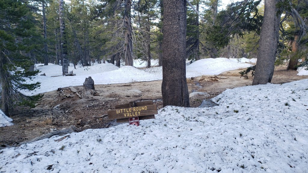
There is a well-traveled boot track through 50% snow cover following the trail route up from Round Valley to Wellman Divide. Round Valley itself is largely clear of snow.
Deer Springs Trail is clear of snow from the Highway 243 trailhead to near the Marion Mountain Trail junction. The 0.6 mile from there to the Fuller Ridge Trail junction averages 40% snow cover. Once Deer Springs Trail leaves the PCT at the Fuller Ridge Trail junction, snow cover averages only about 10% up to Little Round Valley, with many lengthy clear sections. Snow cover remains 70% and heavily drifted through Little Round Valley, and there is no predominant boot track that accurately follows the trail route. Some of the designated camping areas are now largely clear. Above Little Round Valley snow cover averages about 50%, but with an extended central portion under 70% snow cover, and conversely the uppermost exposed switchbacks now less than 20% snow covered. Following the actual trail route is becoming easier, while the various winter season boot tracks have now largely melted out and are invisible and/or of little use. Cautious navigation is required on Deer Springs Trail, especially through and above Little Round Valley. Spikes can be useful (but are no longer required), especially for descending.
South Ridge Trail is clear of snow to Tahquitz Peak on the southern approach from South Ridge Road, and functionally clear of snow on the northern approach from Chinquapin Flat/PCT. The latter 0.4 mile section has three tiny snow patches remaining, but all have excellent tracks with easy steps to follow through the snow and do not require spikes. Fourteen recent treefall hazards on the trail were removed by the Trail Report in May, and trail trimming is undertaken regularly. South Ridge Road remains closed to vehicle traffic and will reopen once graded, possibly later in June.
Willow Creek Trail [surveyed 11th June] is frankly a slow, messy hike for a couple of miles. At least 48 treefall hazards remain across the trail, most of which are large and some are challenging to hike around (or over). There are four large trees down between Saddle Junction and the Skunk Cabbage Meadow junction, and then a further 38 trees down on the next 1.5 mile Forest Service section until the State Park boundary. At least another six trees are down on the State Park section of trail up to Hidden Divide. Some of the section with the most trees down – between Willow Creek and the State Park boundary – is also disappearing under thick whitethorn. The huge amount of work that Bill Rhoads and I undertook to clear whitethorn along this trail in 2020 was not completely in vain and parts of the trail would have largely disappeared by now otherwise, but the whitethorn does make some treefall hazards more complicated to negotiate.
Marion Mountain Trail is now clear of snow to the PCT/Deer Springs Trail. There is significant water flowing in the trail in its uppermost mile, along with half-a-dozen notable treefall hazards.
The Trail Report removed all 38 treefall hazards, plus many branches and other debris, from Spitler Peak Trail in late May and early June this year, bringing the total removed to at least 85 since July 2021. Several minor washouts from this past winter in the upper switchbacks have significantly impacted the tread in places; these are minor for hikers, but the trail is not passable to stock.
Black Mountain Trail is clear of both snow and treefall hazards. Boulder Basin campground reopened on 8th June.
Seven Pines Trail is clear of snow to 8300 ft elevation (about 2.5 miles up from the trailhead). The crossing of the very swollen North Fork of the San Jacinto River at 1.5 miles (just after the State Park boundary) is currently perilous and not recommended for most hikers. This may remain a tricky crossing into July. Patchy snow cover steadily increases between 8300 ft and the junction with Deer Springs Trail/PCT (at about 8700 ft), but overall averages about 20%. Some drifts obscure key switchbacks on the upper trail, and navigation, always a little tricky on this trail at the best of times, will be challenging for those not thoroughly familiar with this route. Of seven new treefall hazards on the trail below the snow line, six were removed by the Trail Report in late May, and a good start was made on clearing the trail of branches and other debris. Dark Canyon Road – the access for the Seven Pines trailhead – remains closed to vehicles for the foreseeable future.
The Caramba Trail from near Reeds Meadow through Laws Camp and on to Caramba, and the Cedar Trail from Willow Creek Trail to Laws, are euphemistically described by the Forest Service as “not maintained”. In reality both trails no longer exist and are so heavily overgrown I strongly advise hikers do not attempt to follow them (regardless of how much you may trust a certain app). An informal use trail to Laws is much more direct, relatively well maintained, and avoids all of the very challenging bushwhacking of the unmaintained trails (some local hikers dubbed it the “King Trail” when I established the route in 2019). It leaves the Willow Creek Trail exactly 1.0 mile from Saddle Junction (0.46 mile from the Skunk Cabbage turning), descending largely on established deer trails for 1.2 miles, meeting Willow Creek just upstream from the old Laws Camp. Of ten trees down on the King Trail [surveyed 11th June 2023], three have been removed, but none of the remaining seven are significant hazards. From Laws east to Caramba the route of the original Caramba Trail has been well-cairned by myself and others and can largely be followed with careful route-finding. My autumn 2022 survey counted 97 trees down on this 2.1 miles of trail. It is especially obscure 0.1-0.3 mile east of the Willow Creek crossing, becoming more obvious near Caramba. Very cautious navigation is advised throughout the area.
SNOW DEPTHS
Measured on 10th-12th June 2023. The first number is the current average snow depth, followed in parentheses by the maximum depth recorded in winter 2022/23 where known. Note that broad averages are given; due to drifting in strong winds, and the differential effects of melting (and of rain on snow in some March storms), there is considerable inconsistency of depth. Altitudes and PCT Miles are approximate.
San Jacinto Peak (10810 ft): 12-18 inches, many large clear patches developing and snow cover about 50%, but drifts 2-4 feet deep remain in places, especially on East Ridge (105 inches on 31st March)
Little Round Valley (9800 ft): 20 inches, about 70% snow cover, drifts 2-4 feet deep in places.
Wellman Divide (9700 ft): 9 inches, ranging from 0-25 inches (70-75 inches on 3rd and 31st March)
Annie’s Junction/PCT Mile 180.8 (9070 ft): 8 inches, snow cover 40% here (80 inches on 3rd March)
Long Valley (8600 ft): 0 inches (60 inches on 3rd March)
Strawberry Junction/PCT Mile 183.2 (8100 ft): 0 inches
Saddle Junction/PCT Mile 179 (8070 ft): 0 inches (48-50 inches on 3rd March)
Devil’s Slide trailhead at Humber Park (6550 ft): 0 inches (46 inches on 3rd March)
Idyllwild (at 5550 ft): 0 inches (45 inches on 1st March)
PCT Mile 151 at crossing with Highway 74 (4800 ft): 0 inches (13 inches in first week of March)
While all time and labor is volunteered, the San Jacinto Trail Report uses small private donations to help cover modest operating costs. Every year has its unique challenges, and a remarkable 2023 is clearly no exception. Your contribution keeps the Report available to all, free from advertising or paywalls, and independent from agencies. If you have found this Report useful, please consider using this link to the Donate page. Zelle, Venmo, and PayPal are all options. Thank you so much for your support.


Hi Jon, Rode my e-bike up black mtn rode on June 7th and found patches snow at 7700 ft,,, hereâs some picsâ¦I saw Forest Ranger and she said she was o-ending campgrounds including Boulder Basin next day June 8th⦠So nice up there ! Thanks !Â
Sent from Yahoo Mail for iPad
LikeLike
Thank you Morgan
LikeLike
I appreciate the update on pesticide spraying, and closure at Humber Park. With our insect population down to 10% of what it was 50 years ago, and other area closures for the endangered red legged mountain frog, why should we spray to kill insects?! As Joni says, leave me the birds and the bees please!
Thanks for sharing great information Jon!
LikeLike
My understanding is that the spraying is of specific black oak trees to minimize the impacts of the invasive Golden-spotted oak borer, which is devastating the black oak population here in Idyllwild. The Forest Service would be better placed to answer your concerns however. Safe hiking, Jon.
LikeLike